Introduction
People are altering the native ecosystems of Amazonia and the Cerrado region through their efforts to derive sustenance and wealth from agriculture ranching and timber harvest. These land-use activities provide an important flow of food fiber and other products to human society, but not without a price. Agriculture ranching and logging disrupt the storage and flow of energy carbon water and mineral elements in native ecosystems and may therefore damage those ecological processes that sustain life in these regions. It is the goal of the large-scale biosphere atmosphere experiment in Amazonia (LBA) to conduct scientific investigations that determine the ecological effects of land-use activities in Amazonia and the adjoining Cerrado savanna biome. These investigations should allow for the identification of those forms of land-use that provide the maximal flow of goods to human society with the minimum disruption of life sustaining ecological processes.
In this paper, we summarize current knowledge of land-use in Amazonia and the Cerrado regions and identify some significant gaps in this knowledge. The biggest challenge in this review is presented by the great diversity of land-use activities that can be found in the region. The managers of rural Amazonia’s soils, forests, and rivers utilize these resources by replacing high species rich forests with African forage grasses by clearing forest for agriculture through the harvest of forest fruits nuts and game through timber high grading placer mining for gold industrial mining and traditional and industrial fishing.[1-11] Each of these practices asserts a unique influence on the regions’ biota. Evergreen’s deeply rooted forests are replaced by seasonally dormant forage grasses or short-lived food crops,[3, 4] agro-extractivist deplete some game and plant species while timber high graders opened the humid under stories of burn resistant forest to the ravages of fire.[1, 2, 4, 5, 6, 11] Placer mining releases sediments and mercury into streams, [5, 7, 8, 9] while industrial mining spurs spontaneous mining towns beyond the fences of its development sites;[12] geleiro ice boats sweep seasonal varzea lakes of the fish that once supported traditional ribeirinho populations.[10]
Just to the south and east of Amazonia, the giant Brazilian Cerrado mosaic of Evergreen woodland species rich Savannah and grassland ecosystems is undergoing a different set of transformations. Extensive grazing of natural grasslands is giving way to cattle production on planted pastures, while the well structure oxisols of the region are tilled and fertilized for the production of soybeans rice and other annual crops. Along with the settlement of the Cerrado has come an increase in the frequency of fires that may have changed the structure and function of Cerrado visitation in ways that are difficult to measure.[13-16]
It is within the context of this complex array of land-uses that the LBA science plan is being formulated. The integrated research programs will study the impact of Amazonian and Cerrado land-use on carbon storage trace gas fluxes and nutrient dynamics. But synthesis of the large amount of unpublished and recently published information on land-use is needed to inform this planning process and to improve the quality of the proposals and science to follow. In this document we review information on the major forms of land-use in their geographical distribution and their probable trends over the next decade. We also discuss these land-uses as they relate to the occurrence of El Niño/ southern oscillation rainfall anomalies and projected reductions in rainfall.
The lion’s share of research on land-use in Amazonia has focused on regions of closed canopy forests, which comprise about 80% of the Brazilian legal Amazon. This review is divided into a large section concerning closed canopy forests of Amazonia, followed by a smaller section concerning the savanna-like, Cerrado vegetation.
Closed canopy forests
Spatial and temporal patterns of deforestation
The conversion of closed canopy forests to pasture and cropland can be mapped using imagery of the Landsat thematic mapper satellite. Unlike the Cerrado biome of Brazil, the closed canopy forests of Brazilian Amazonia have been mapped entirely by different research groups using TM imagery for several time periods.[17-19] A Pan-Amazonian map of deforestation has been prepared using the relatively coarse resolution (16 km pixels) NOAA-AVHRR imagery.[20]
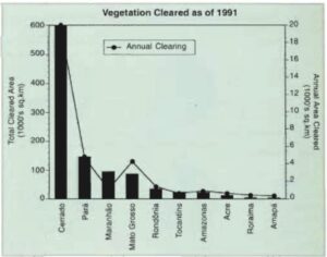
Figure 1. The total area of natural vegetation cleared as of 1991 and the average annual rate of clearing from 1988 to 1991 for the 2-million-km2 Cerrado region and the states of Brazilian Amazonia. Data for the Cerrado are from Klink et al.[95] and are based on land-cover trends registered in the IBGE agricultural census from 1970-1985. Data for Amazonian states are from INPE,[18] and included areas of “old” (pre-1960) deforestation. The total area od Amazonian forest clearing as of 1991 was 426,000 km2.
The clearing of closed canopy Amazonian forest has been concentrated in the east and South of the region in the Brazilian states of Pará, Maranhão, Mato Grosso, and Rondônia, in decreasing order (Figures 1 and 2) (Table 1). The two recent efforts to map deforestation in Brazilian Amazonia using prints of Landsat TM images have yielded remarkably different estimates of the total area cleared in each state. For 1988, the estimate of the total area deforested of Skole and Tucker [17] are lower than those of INPE [18] by 20% (Rondônia), 30% (Mato Grosso), 33% (Acre), 40% (Amazonas), and 50% (Tocantins), but are also quite close for Pará and Maranhão. The lower estimates of Skole and Tucker [17] may be a result of the coarser resolution employed by this group (1:500,000) compared to the resolution employed by INPE (1:250,000) are the fact that Skole and Tucker [17] use it as a single spectral channel compared to three employed by INPE. Whatever the cause, there continued to be large uncertainties associated with this most basic parameter of land-use change in Amazonia.
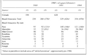
Table 1. Estimates of the area of savanna vegetation (Cerrado biome) and closes-canopy forest (Brazilian Amazonia) cleared as of 1988, 1991, and 1994
The rate of clearing of closed canopy Amazonian forests was highest from 1978 to 1988 (21,000 km2 per year), declined until 1990/91 (11,000 km2 per year) and then increase it during the period from 1992 to 1994 (15,000 km2 per year) [17-19] (Table 1). This temporal sequence of forest clearing estimates was made using Landsat TM imagery and is the world’s best record of deforestation in a large tropical forest region. Forest clearing trends beyond 1994 are not yet published. However, the largest number of Amazon fires detected by the NOAA-AVHRR satellite since 1987 were registered in 1995,[21] suggesting that forest clearing may have increased further since the last INPE map of deforestation was produced in 1994.
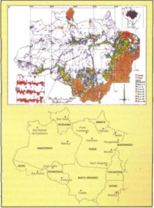
Figure 2. Clearing of closed-canopy forests in Brazilian Amazonia (top panel) based on 1988 digitalized tracings of clearings as interpreted from Landsat Thematic Mapper paper prints ad 1:500,000 (from Skole and Tucker [17]), and state boundaries and cities of Brazilian Amazonia and adjacent states of the Cerrado region (lower panel).
What forest alterations are missed by TM-based analysis?
The dichotomous forest versus non-forest approach to mapping land-use activities neglects important alterations of the forest that are difficult to measure reliably using Landsat TM imagery. In this section we discussed the problem of quantifying the area of forest affected by selective logging and fire and the problem of understanding the fate of cleared lands.
Logging
More than 4000 km2 of forest is altered through logging each year in Pará state alone (see: Logging and mining: the case of Pará state). This is roughly equivalent to the area of forest that is cleared each year in this state (see Figure 1), and about half of the total area cleared annually in the early 90s [18, 19] (see Figure 1). Logged forests frequently burn because of the large fine fuel loads and drier microclimate of the litter layer in logged versus primary forest.[6, 22] Estimates of deforestation based on visual inspection of TM print may capture some small portion of the very pronounced logging scars of the most intensive forms of selective logging such as those found within a few km of Paragominas. But even these logging scars disappear from TM scenes whizzing three years time as the logging roads and loading zones are grown over with recovering vegetation.[23]
Fire scars
The area of forested or agricultural land that burns each year is one of the most important parameters needed for the LBA science campaign, since burning influences virtually all the ecological processes that the campaign will address. INPE’s hot pixel mapping of fires has provided important data on this issue, demonstrating that hundreds of thousands of individual fire events occurred in Amazonia in 1987, for example, representing >200,000 km2.[11] However, these maps of AVHRR pixels that exceeded thermal thresholds are difficult to translate into precise areas of fire scars by vegetation cover type because of problems of pixel saturation by small fires, the prolonged smoldering of woody biomass, and the coarse resolution of the data (1 X 1 pixels).[24, 25] Forest ground fires are particularly difficult to detect from space.
Pereira and Setzer [26] Have also demonstrated that Landsat TM imagery can be used to detect fire scars in Amazonia on the basis of spectral signatures. Using this approach, Nelson [27] inspected TM print for all of Brazilian Amazonia with ground truthing at several locations and measured >500 km2 of burnt primary forest that had undergone crown deaths and another 1,000 km2 of primary forest that had undergone deleafing from ground fire during the 1983 drought. He predicts that these values greatly underestimate the area of primary forest that burned during this severe El Niño-related drought.
“People are altering the native ecosystems of Amazonia and the Cerrado region through their efforts to derive sustenance and wealth from agriculture ranching and timber harvest.”
Using visual interpretation of a 1988 TM image, a 1,000 km2 fire scar was mapped in an area of mostly logged forest north of Paragominas.[28] This scar was probably not included in the regional deforestation estimates, since it appeared to have substantial forest remaining. However, a site visit revealed that the forest remains visible in the satellite image were actually the crowns of remnant trees persisting in an impoverished forest. Local landholders stated that portions of this forest had burned three times.[29] The area of the single scar represented ~5% of the 1988 estimate of forest clearing. In another forest ground fire observed in Paragominas, 45% of all trees >10 cm diameter at breast high were killed.[30] Forest ground fires are difficult to map using Landsat TM imagery but assert a profound influence on forest structure and function.
The fire scar near Paragominas underscores the important interaction between logging and forest flammability. By opening the forest canopy and increasing the fine fuel load on the forest floor, logging greatly increases the risk that the forest will experience ground fires that are initiated in adjacent agricultural lands.[6, 22]
The frequency of fire may increase in the future through positive feedback with regional climate change. The reduction in rainfall predicted by most modeling experiments done thus far (e.g., references 21, 32 and 33, but not predicted by Polcher and Laval [34]), may exacerbate drought induced forest burning which in turn may lead to less evapotranspiration, less rainfall and more fire.[4]
The fate of cleared land
By 1994, about 470,000 km2 of Brazilian Amazonian forest had been cleared and replaced with managed (disk-tilled fertilized and replanted) pastures of African forest grasses, “degraded” pastures that have large amounts of shrubs and non forage herbs, fields of animal crops, perennial crops, and re-growing forests on abandoned pasture and cropland.[18] Knowledge of the aerial extent of each of these vegetation types is important because they vary greatly in the amount of carbon they store or sequester from the atmosphere in their patterns of runoff and evapotranspiration and in their patterns of trace gas flux.[1, 3, 4, 35-49]
In the absence of Amazonian wide analysis of the aerial coverage of different anthropogenic ecosystem, we can turn to case studies for an understanding of the current distribution and temporal trends of these lands cover types. The Bragantine zone, east of Belém, is the oldest agricultural frontier in Amazonia and provides a glimpse into the future of Amazonian landscapes that are currently dominated by small holder farmers and close to markets. Although this region is characterized as “old deforestation” by the Amazonian-wide efforts to map deforestation,[17-19] analysis of Landsat TM scenes and field studies in three Bragantine counties reveal that land-use in this region is quite dynamic. After nearly a century of agriculture, primary forest had been reduced to 15% of the landscape and was concentrated along streams on sites where agriculture was unviable. Old secondary forests (more than 20 years) comprised only 23% of the area. Those portions of the landscape that are still in use by farmers including young secondary “fallow” forests (29%), pastures (13%), and agricultural crops (9%) made-up half of the land area [49] (Figure 3).
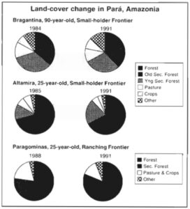
Figure 3. Land-cover change in three frontiers of Amazonia showing the large area of “active” pasture, cropland, and young secondary forest in the Bragantine zone, the large area of forest that is still found in the younger frontiers of Altamira and Paragominas, and the apparent tendency toward land abandonment in these 25-year-old frontiers. The forest category includes areas of selective logging. The Bragantine Zone study used TM imagery from 1984-1991, for the counties of Peixe Boi, Nova Timbonela, and Capanema. Total Area was 137,835 ha. Classification conducted in IDRISI was tested using a farmer’s map of 35 agricultural plots during the dates of the images and additional field visits.[100] The Altamira study employed TM images from 1985-1991 in a study area of 233,466 ha. Classification was tested through field work, and through a more theoretical evaluation of the six-band spectral pattern of each land-cover class.[50, 54] The Paragominas study covered 347,500 ha on 1988-1991. The classification was conducted in IDRISI and tested in the field.[101]
In a similar change detection study conducted near the town of Altamira [50] a 25-year-old frontier that was initiated as a colonization project, 2/3 of the forest was remaining and 1/4 of the landscape was covered by pasture, crop fields and young secondary forests [51] (Figure 3). In this region, the total area in pastures and croplands declined slightly during the six-year study period, but the portion of this area in young secondary forests increased by 8%. This region does not have good highway connections with major urban centers and may be undergoing a process of agricultural stagnation.
During a three-year period in Paragominas one of the centers of the large government subsided ranches implanted during the 1970s, the area of forest declined by 4% and the area of pasture and cropland declined by 6% (see figure 3). Paragominas contrary to Altamira, has excellent highway links with Belém, and has the highest concentration of sawmills in Amazonia. The reduction in area of active pasture and cropland in this region may be a result of the intensification of cattle production on smaller areas of pasture.
In Paragominas and Altamira “forest” what’s the most common type of land cover after 25 years of agricultural settlement, but had been reduced to the margins of streams after 90 years of settlement in the Bragantine region. The “forest” category includes those forests that had been logged or that had experienced ground fires, which could be most of the forest in the case of Paragominas. 66% of the land within a 25 km radius of Paragominas still supports forest cover, but only 6% of this land supports forest that has been neither logged nor burned.[52] In Altamira and Paragominas there appears to be a trend toward abandonment of pasture and cropland followed by second forest regrowth such that pastures and croplands occupied less than half of the land originally cleared for agriculture. In Altamira where small-scale farmers are prevalent much of the young secondary forest may be agricultural fallows and hence not truly abandoned. In Paragominas, we’re only 4% of the land is occupied by smallholders secondary forests are mostly abandoned pastors that may also come back into production through faster reformation.
These and other studies [1, 36, 54-60] show that phenomenon of land abandonment followed by forest regrowth in Amazonia appears to occur following all but the most intensive forms of pasture management such as those that involve mechanization and/are numerous cycles of burning herbicide application and overgrazing. Where pasture management has depleted soil seed banks of tree species killed the residual tree roots that can give rise to new shoots through sprouting and introduce it populations of seed and seedling consuming ants and rodents the reestablish moment of tree cover following pasture abandonment can take >5 years and longer if these sites burn periodically.[53 59]
One particularly promising approach to the mapping of secondary vegetation involves the modeling of spectral end members.[62, 63] This approach may also provide a technique for mapping logging and fire scars that are otherwise difficult to see in satellite images. It isn’t clear if this approach would allow for the satellite-based classification of secondary forests by age biomass or species composition over large areas of Amazonia, since the floristic composition of secondary forests is highly variable from one region to the next.
The macro causes of deforestation
This facial pattern of forest clearing in Brazilian Amazonia has closely tracked the construction of highways. The Belém-Pará highway (BR-010) in eastern Pará and Maranhão, the BR-364 in Mato Grosso, Rondônia, and Acre, the Transamazon Highway in central Pará and Amazonas, and the PA-150 in East Central Pará (see Figure 2) have all become corridors for human settlement and forest conversion in rural Amazonia. In tandem with highway construction, government programs have provided land are fiscal incentives for agriculture, leading to focal points of settlement and forest conversion. For example, much of the “old deforestation” east of Belém and Maranhão occurred near the turn of the century through agricultural clearing by immigrants from Brazil’s drought stricken Northeast, who were provided land in the region through a government settlement program.[62] In the 1970s, The Brazilian government’s program to promote faster establishment resulted in clearing along the Belém-Brasília highway in eastern Pará, giving rise to towns such as Paragominas.[63, 64] Numerous colonization programs in all states of the region but particularly in Mato Grosso, Pará, and Rondônia led to clearing by landless immigrants that were put to the region by these programs and pushed from their land in southern and northeastern Brazil by industrial agriculture and drought.[56, 64, 65, 66, 67] In recent years, government subsidized programs to promote the colonization of rough areas of pristine forest have declined. Land is still being distributed by government agencies, but direct financial incentives to clear forest have dried up. FNO (Fundo Constitucional do Norte), which is the major government credit program for Amazonian farmers and ranchers, provides funds for agricultural recuperation of lands that are already cleared but not for new clearing.
“A mechanistic understanding of the role of drought and land-use practices is needed to better project the future importance of forest fires.”
Forest clearing also occurs where it is not planned. Expanding agricultural frontiers can be found around the Manaus’s free trade zone, near Santarém, Pará and Cuiabá. The railroad corridor of the Carajás iron mine has fostered forest clearing and charcoal production that was not anticipated in the mine’s development plan.[68, 69] The potential for unplanned spontaneous forest clearing may increase greatly in the future as industrial mines provide new foci of employment and forest access roads to Brazil’s land seeking citizens. For example a $160 million loan was recently approved by the World Bank (international finance corporation) to finance a kaolin mine in northeastern Pará that would provide 7% of the world’s supply of this clay mineral, and that will include access roads, a 180 km pipeline and employment for 5000 laborers.[12] Dozens of similar mining operations are nearing the end of the licensing process. Information on the spatial distribution of new industrial mines allow us to identify those regions that should have the greatest changes in access to forested regions and where opportunities for employment and land acquisition will rise for the landless poor. Most new mining operations are currently being planned for western and Southern Pará, northern Amazonas and Rondônia states, but the availability of electricity may encourage more mining in southern Pará (see: Logging and mining: the case of Pará state).
The proximate causes of deforestation
People clear Amazonian forest as the first step in pasture formation and crop field preparation. The biomass of the felled forest is allowed to dry and then burn it, providing an input of nutrient rich ash to the soil surface. This ash promotes the growth of western forage grasses and crop plants, but this fertilizing effect declines with time, especially in crop fields where weed invasion and declining levels of soil fertility restrict the productive period of recently cleared land to 1-3 years. It is the rapid decline in crop productivity that forces small-scale “slash and burn” farmers to clear more forest.
Although small-scale farmers are numerous, and are dependent upon frequent clearing of forest for their agricultural production, it is the large-scale landholders that appear to be responsible for most forest clearing in Amazonia. Fearnside [70] has analyzed the relative contribution to the forestation of smallholders (lots <100 ha) versus large scale and holders by conducting regression analysis of census data and deforestation estimates for the nine Amazonian states. He estimates that ~30% of forest clearing in 1991 can be attributed to smallholders and 70% to large scale and holders. This is not to say that smallholders do not become large scale and holders as they accumulate land and cattle and as their household labor pool expands.
The logic that leads landholders to farm cattle pastures may have changed in recent years. In the 1970s and early 80s, large scale landholders formed extensive cattle pastures to establish ownership over land and to “capture” the escalating land values and government subsidies.[64, 71, 72, 73] As government subsidies for pastures formation have disappeared and as new cattle pastures management systems have emerged, the logic behind cattle pasture formation appears to have evolved. Cattle pastures are now the best means by which rural Amazonians can accumulate the wealth generated by logging artisanal mining or agriculture – the “so besides from nature” that drives today’s Amazonian land-use systems.[72] For both large and small scale landholders [74] cattle pastures provide only a small profit margin (last then $10/ha/yr) using the traditional extensive model of pasture management,[75] but investments in pasture are highly liquid compared to investments in perennial crops or forest management for timber. The price of beef is more stable than other agricultural products and the market for cattle is a ubiquitous, such that the bovine that becomes a form of alternative currency on the agricultural frontier. Cattle pastures therefore represent an inflation free, liquid investment that strengthens legal claims to land. In addition, the current rate of pasture formation may reflect demographic phenomena interacting with economic conditions at the household level, promoting widespread shifts to investment crops from production based on annual crops.[76,77]
An unimportant factor making Amazon ranching an attractive land-use is the low price of land compared to the traditional ranching regions in central and South Brazil. Land prices have increased dramatically in central and South Brazil due to the increased cultivation of agricultural export crops (e.g., soybeans). The mainland price for agricultural pasture land in the states of São Paulo, Minas Gerais and Goiás (place of origin of the majority of Pará ranchers) was 3.6 times greater than in Pará in the early 1990s, $1,541 versus $427, lowland prices and therefore lower costs of capital explain why eastern Amazonia ranchers can compete in the national market for meat even though they are far from consumer markets.[75]
The logic behind pastor formation continues to evolve. The future of Amazonian cattle ranching may be found in regions such as Paragominas a ranching and logging center of eastern Amazonia were semi intensive cattle pasture systems involving disking fertilization and new types of forage grasses (especially Brachiaria brizantha) generate average annual profits of $50/ha.[78] In this same region, even greater profits are generated by small-scale dairy production systems does not generally involve new forest clearing in the Paragominas region.
Other land cover dynamics are also in evidence. Although substantial concern has focused on pasture formation (given ecological impacts) some deforestation leads to the adoption of perennial crops, which is a form of agricultural intensification. This is an important process from the perspective of achieving sustainable development.[79]
Hence, in the place of government loans and subsidies the major source of capital driving expansion of the agricultural frontier today may be timber and minerals [65, 78, 80] with cattle pastures acting as a form of “savings account”. The trajectory of new clearing is tied to the geographical distribution of logging gold mining and industrial mining, as we illustrate here with a review of logging ranching and mining in the state of Pará.
Logging and mining: the case of Pará state
The state of Pará (see Figure 2) is the source of 80% of the timber harvested from Brazilian Amazonia. Hence, most of the Amazonian timber industry can be understood through analysis of logging in this eastern Amazonian state.
Today most timber is extracted at low intensity over large areas of forest. This “extensive” system is characterized by extraction of only high value species with little planning of logging roads and skid trails. The deflation of forest timber stocks is seen in parts of the estuary region of the Amazon River where logging has been going on for centuries.[81]
More recently, there has been a trend toward more intensive logging in old frontier areas along the Belém-Brasília highway. Here, 100 or more species are harvested, and significant damage is inflicted on the canopy and ground surface through tree felling and log extraction. Forest leaf canopy cover decreases 50% and up to half of the forestry basal area is lost through direct harvesting toppling or damage.[80] Unfortunately, this more aggressive harvesting has not being accompanied by measures to guarantee future harvests. Unless forest management methods are implemented, timber extraction in Pará may have a short life span. Forest management is not utilized in most areas of Pará.
It is tempting to describe the wood industry in the Brazilian Amazon using summary statistics and averages, but this approach provides only a limited amount of information about the sector. There are very few central tendencies in this industry, but there are some patterns that can be detected. Five factors influence the characteristics of the wood industry: 1) local extent composition (especially the presence of high value species); 2) transport options (fluvial versus terrestrial); 3) availability of investment capital; 4) market options (domestic versus export); and 5) local social cultural traditions. The role of these factors is evident in Pará state, where most logging activities in the Brazilian Amazon are concentrated. We have identified five models of logging in this state – two in “várzea” (floodplain) Forests and three in the “terra firma” (upland) forests.[80-83] In considering the impact of logging on carbon stocks nutrient cycling and so forth, it will be important to design research that incorporates the different intensities of logging that are found in Amazonia.
Amazonian logging is emerging as a major growth industry. At present, the logging industry in Pará harvests some 8.3 million m3 of round wood/ear (IMAZON database). Considering that, on average, 20 m3 a forest are logged in Pará state each year. But the wood sector is not static. The Brazilian economy is projected to grow at 7% in the period marking the transition from the 20th to the 21st century. If this occurs and if the Amazon would industry experience, the same level of gross wood production will double to 16,000,000 m3/yr in 10 years. In this case the area of forest logged each year would be approximately 8000 km2. Assuming a cutting cycle of 70 years in the absence of forest management [84] the total area of the state of Pará needed to double present day round wood production (i.e., supply 16,000,000 m3 of hardwood per year) on a sustainable basis would be about 560,000 km2 (8,000 km2 X 70-year cutting cycle) or half the area of the state. Of course, if production were to double over the next 10 years, it is unlikely that it would then suddenly stabilize. If the projected 7% annual growth in timber production continued for an additional 10 years, we calculate that the annual production would have exceeded a level beyond what could be sustained given the available area. Therefore, although the impacts of this activity are relatively small now, increasingly it is the drive for wood that will be a catalyst determining how Amazonia is occupied and the associated impacts.
There are two additional logging related topics that merit special attention. The first is vines. The long-term sustainability of a logging economy in Amazonia may be severely jeopardized by vines. This plant group is favored by gaps of debris and stem cutting (vigorous sprouters) — the very disturbances that logging promotes. Vine cutting conducted in conjunction with forest management may have an effect on regional rainfall. Vines often have root systems that extend deep into the soil (10 meters or more) and therefore vines might be responsible for a significant fraction of forest evapotranspiration during dry periods [85]. The removal of vines from the forests of eastern Amazonia may reduce evapotranspiration, with concomitant effects on regional rainfall.
Finally, just as forest management could affect the original landscape, so two changes in the original landscape might affect forestry. Particularly worrisome for sustainable forestry is the process of forest fragmentation. As forested landscapes become more fragmented there may be reductions in pollinator services provided by birds and insects the incidence of seeds and seedling predation might increase fire and wind through disturbances may become much more common and the movement patterns of large carnivores that could exert important ecosystem control functions might be impacted. These landscape level processes and feedbacks are poorly understood and merit study as they are likely to be important in the maintenance of healthy forests.
The state of Pará also has more mineral extraction than any other state in Brazilian Amazonia.
Gold mining is the most common extensive style mining approach in Pará. There has been considerable environmental damage as a result of gold mining. Mercury contaminates waterways and streams because clouded with silt dislodged when riverbanks are dismantled by water hoses. Only a small fraction of the gold in the deposits is actually recovered (see references 5 for an overview and 7, 8, 9).
Industrial mining also occurs in Pará. The best example is iron or extraction in the Carajás Mine in southern Pará. Industrial mining is of special concern to the Amazon science plan as a predictor of future patterns of forest clearing. The opening of new mines in southern Pará where electricity is available and licenses to mine have been solicited could lead to deforestation zones similar to those found along the Carajás railway corridor. Mines that are located on rivers and that transport their product by barge or pipeline have the potential to increase the sediment load and to introduce toxins into these rivers.
Gold mining is far more pervasive than industrial mining at the present, and maybe influencing more river systems. Although the release of mercury into river systems through gold mining has been fairly well documented, the effects of mining on stream sediment loads string chemistry fisheries and forests that surround mining camps have not been described in detail. An understanding of land-use effects on Amazonian surface waters will require field studies of this widespread form of mining.
Future trends
The present spatial distribution of resort extraction activities determines in large part the future pattern of human occupation. In the case of Pará, the maps provided in Figure 4 show that farming ranching and logging activities are linked to established road networks. The areas bordering roads to a distance of 5 to 50 km have been cleared and are used mainly for ranching. In the proximity of towns, roadside land is frequently devoted to agriculture. Logging activities are practiced behind the ranches to a distance of 50 to 100 kilometers. Where would have exceptionally high value (e.g., mahogany) is involved, loggers may go as far as 500 kilometers from the mill to insert of logs.[82] In these cases, they actually build the roads themselves.
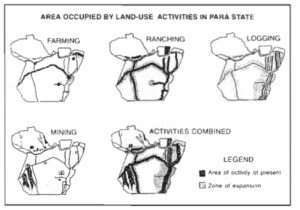
Figure 4. Current and projected areas of agricultures, cattle ranching, selective timber harvest, and gold and industrial mining in the state of Pará.
(Source: IMAZON)
At present only about 10% of the state has been affected by these resource use activities, but this is changing rapidly. Expansion trends for the next several decades will likely result in the occupation of 40% to 50% of the state (Figure 4). Industrial growth will continue spreading into western Pará including the varzea areas; while southern Pará, an area already is covered with many roads, will experience increasing pressure from logging agriculture and mining activities. Logging and mining are likely to be the dominant activities and deserve special mention.
Logging currently provides the second largest income generating activity for the state. Tropical timber resources continue to enjoy a warm reception on both the national and world markets. Philippine and Malaysian buyers now regularly visit Belém and other wood processing centers such as Paragominas and Marabá. Stocks are valuable mahogany in southern Pará are likely to be depleted before the end of the present century. At the same time, lesser value timber will increasingly be extracted to feed the many sawmills already established along the roadways and in urban centers throughout southern Pará and the Transamazon highway. There is no sign of sustainable logging practices in the region. Moreover, if unchecked the secondary effects of logging which include spontaneous colonization along logging roads and forest fire could foreclose the possibility of future cuts.
Mining has been and will continue to be a key activity in Pará over the next several decades. Between 1975 and 1987 mineral production grew from 0.1% to 7.0% of the state’s internal production. It currently represents the largest income generating activity for the state and continues to grow in the 1990s. Today nearly 2,800 permits to search for mineral resources hold claim to 16% of the state (120,000 km2), but only a small fraction of the area is being actively exploited. The major limitation to expanding activities in formal mineral extraction is the activities’ dependence on electricity. In southeastern Pará, blessed with electrical power supplies and roads, mineral extraction activities will continue to expand in both the industrial and the gold mining sectors. Southwestern Pará, it’s less developed today, but plans exist to build roads and provide electricity in the near future. Although much mineral prospecting has been conducted in northern Pará, the lack of power lines makes extensive mineral extraction activities unlikely in the near future.
As Pará’s natural resources become exhausted, urban migration poverty and ecological stress increase. In 1991 Pará’s urban population accounted for more than 50% of the state’s approximate 5 million people.[86] This is the first time that urban populations are larger than rural populations in the state. As a reflection of this growth, populations in urban centers in Pará have more than doubled in the past 15 years.
Government colonization projects: the case of Rondônia state
Land-use in the state of Rondônia (see Figure 2) has been dominated by large government sponsored projects designed to encourage farmers to settle in forested regions and more recently designed to fix the problems that arose from these settlements schemes. Colonization programs in Rondônia started in the early 70s and successfully attracted thousands of families, mostly from southern Brazil.[56] The first wave of settlers were given forest plots situated on good soils, and the news quickly spread that Rondônia was a land of rich soils. However, only one force of the state is suitable for agriculture, and many of the subsequent farmer colonists achieved only low levels of agricultural productivity compared to the first wave of settlers. The massive influx of colonists led to very high rates of deforestation. From 1978 to 1993 the area of cleared forest in Rondônia went from 4,000 km2 to 40,000 km2 (17% of the state territory) as newly arrived farmers cleared and burned the forest to prepare the soil for agriculture [17, 18, 19, 87] (see Table 1).
The plans for the rural sector of Rondônia developed in the 70s included governmental incentives for the planting of animal and perennial crops. However, the trajectory of Rondônia agriculture has now converged with that of other agricultural frontiers in Amazonia in that cattle pasture is the most common use of cleared lands [88] (Table 2). Rondônia farmers turned to kettle pasture for the reasons cited above (see: Proximate causes of deforestation) but may also have an added incentive in the substantial infrastructure for the sale and processing of beef and milk. In 1994 the state of Rondônia had 13 dairy units and five slaughterhouses.[89] The arrival in 1994 of a single milk producer in Ouro Preto do Oeste (Parmalat) increased the price paid to farmers for milk by 50%.
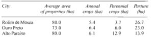
Table 2. Major land-use activities in three different areas in Rondônia.[49] Mean area per property of three land-use practices.
Hence, after a little more than two decades Rondônia has become a clear example of the potential for poorly planned settlement schemes in tropical forest regions to promote rapid and extensive losses of tropical forest while providing little improvement in the lives of those people that the schemes were designed to help. In an effort to mitigate some of these ill effects on Rondônia’s settlement schemes, the government of Rondônia with support from the World Bank has now launched a new program of agro-ecological zoning of the state in an attempt to control the unregulated expansion of agriculture and logging in the region. This program called PLANAFLORO is also intended to improve the state’s rural infrastructure to provide credit for small farmers to demarcate and create extractive reserves and to communities of Amerindians. The performance of this ambitious zoning program should provide valuable lessons about the potential for this approach to rural land-use planning to direct the course of rural development in Amazonia.
Emerging frontiers: the case of Acre state
Acre state in western Amazonia is symbolic of regions of “incipient” frontier expansion. While Acre was linked to the rest of Brazil only by an unpaved two-lane highway (BR-364) the influx of settlers to the region and the associated forest clearing were slow. As of 1994 only 12,000 km2 (80% of the state territory) had been cleared.[18, 19] Acre has now been selected however as the “gateway to the Pacific”; an all weather Rd. may connect to Brazil to the Peruvian seacoast via Acre in the coming years. Hence, Acre represents an opportunity to accompany the process of rural colonization and frontier expansion at an early stage.
Acre also contains some of Amazonia’s most important experiments in land-use categories, designed to reconcile the rural economic development and forest conservation. Two of the largest extractive reserves in Amazonia, the Chico Mendes (one million ha [1]) and upper Jurua (about 500,000 ha) are located in Acre. These reserves allow the communities of rubber tappers in Brazil not harvesters that live within the boundaries together forest products and practice shifting cultivation while placing constraints on the amount of forest that can be converted to agriculture.
The climatic stratification of research in Amazonia
Virtually all the ecosystems processes that will be studied by the LBA campaign are affected by rainfall regime. Seasonal and interannual drought influences net primary productivity, evapotranspiration runoff and stream flow nutrient export and soil microbial processes. The research design of the campaign should be stratified to include gradients of rainfall seasonality and interannual variability.
Both total rainfall and rainfall seasonality vary from a general gradient that runs from northwestern Amazonia (high ring and seasonal) to southeastern Amazonia (low rank and seasonal). In São Gabriel de Cachoeira (northwestern Amazonas) annual rainfall is ~4000 mm and >100 mm each month; in Santana de Araguaia add to the transition between closed canopy forests of Amazonia to savanna ecosystems of the Cerrado, annual rainfall is ~1550 mm and there are five months each year with <50 mm of rain (Figure 5). Forest clearing has been heavily skewed toward these areas of seasonal drought; the 2 million km2 of closed canopy forest that have at least three months each year with <50 mm rainfall contained 75% of the forested lands.[3]
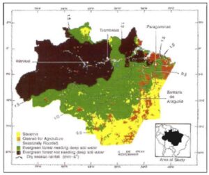
Figure 5. Map of Brazilian Amazonia (Legal Amazon) showing the gradient of dry season intensity from the northwest to the southeast. At the border between closed-canopy, evergreen forests (light green) and savanna (yellow), there is an average of 0.5 mm of rain per day during the driest three-month period of the year. Amazonia’s evergreen, closed-canopy forests that are subjected to intense drought during the dry season rely on water uptake from deep in the soil profile to maintain evapotranspiration.[3] Most of the area of human settlement in Amazonia has been in regions of intense seasonal drought.
(Nepstad et at.[3])
The major source of interannual rainfall variation in Amazonia is the El Niño/ Southern Oscillation Phenomenon (ENSO).[90, 91] ENSO leads to greatly reduced rainfall (30% below average) in eastern Amazonia.[92] Based on a model that tracks plant available soil water (PAW) precipitation and the minimum routing depths necessary to supply evapotranspiration, we estimate that the Evergreen forest in this region deplete PAW to soil depths of >5 m during ENSO events.[93] Field measurements during the 1992 ENSO event found PAW was depleted to >8 m soil depths at one site near Paragominas.[3]
A second focus of research on the effects of drought on forest function should be the zone of transition between closed canopy forest and savanna vegetation. A general reduction in rainfall could lead to a shift in the position of this transition as drought stressed forests become a more flammable and invaded by grasses.[4, 31] The recent frequent occurrence of ENSO events and the predicted reduction in rainfall for Amazonia [31, 33, 94] point to the need to understand forest responses to seasonal and interannual drought.
Recommendations
In sum, TM-base it Amazonia wide analysis of forest clearing are needed as a first order estimate of the general trends in Amazonian land-use. A fuller understanding of the trajectory of Amazonian land-use, however, will require information from other types of study. Land-uses such as selective logging the escape of accidental fires into logged and primary forests and secondary succession on abandoned land can alter the carbon storage nutrient cycling hydrology and the flora and fauna of Amazonian forests but are inadequately detected by thematic mapper based monitoring. Some key information needs that could be addressed by the LBA science campaign for Amazonia include the following:
- Mapping of the forestation across Brazilian Amazonia is conducted at 2-3 year intervals by INPE and should be continued. It should be extended to non-Brazilian Amazonia and to the Cerrado region it has never been conducted for all Amazonia using Landsat TM.
- Mapping of the expanding frontier of selective logging classified according to logging intensity. The search would require information on the spatial distribution of sawmills their production rates and their harvest intensities, and might draw on rather and high resolution aircraft-mounted sensors.
- Mapping of fire scars. Such an effort might require high resolution mapping (perhaps from aircraft) with ground truthing over sample landscapes. Forest ground fires are particularly difficult to map and may be affecting a large area of logged and primary forests. Moreover, a mechanistic understanding of the role of drought and land-use practices is needed to better project the future importance of forest fires.
- Modeling of secondary forest dynamics. Information is needed on the rates at which agricultural land is abandoned to secondary forest regrowth and the amount of time that passes before this secondary forests are brought back into production through new clearing. This information will probably require a combination of remote sensing studies in combination with ground surveys that characterized the land-use strategies adopted by farmers and ranchers. Measurements of secondary forest biomass from space using radar, for example would greatly facilitate this research effort. Such studies should be conducted by multidisciplinary teams that can couple empirical measures of land cover change with socioeconomic studies that reveal the logic of the land managers that are causing this change.
- The design of the LBA campaign should take into consideration the spatial distribution of rainfall with and without ENSO events.
Cerrado vegetation
The legal Amazon of Brazil contains 850,000 km2 of Cerrado vegetation, concentrated in the states of Mato Grosso (43%) and Tocantins (29%) [17] (see Figure 2). This vegetation is conspicuously absent from the efforts to map deforestation in Amazonia, even though the Tocantins and Xingu reverse find their headwaters in this biome. The effects of land-use on these large rivers have not being studied, even though the aerial extent of native vegetation clearing appears to be larger in these drainage basins than anywhere else in legal Amazonia.
Taking as a whole, the Cerrado biome is the second largest of Brazil after the Amazon rainforest representing 22% of the country are approximately 2 million km2. It is a tropical seasonal savanna with a continuous layer of herbaceous species (mainly C4 grasses) at the peak of the vegetation grows with scattered shrubs and trees that sometimes form a continuous canopy. It has a characteristic flora, which distinguishes it from other Brazilian biomes, such as the Amazonian and coastal rainforests or the northwestern dryland “caatingas”.
Savanna transformation through land-use is difficult to quantify using a dichotomous TM-based approach because the spectral differences between natural and agricultural vegetation are subtler than enclosed forest regions. Moreover, there is some debate regarding the “original” Cerrado vegetation: was it closed canopy woodland (cerradão) that has disappeared through the increased frequency of fire or was it primarily open savanna (Cerrado strictu senso)? There has nonetheless been progress in mapping the land cover of the region. EMBRAPA-CPAC has mapped the land cover (native vegetation, pastures, cropland) of Goiás (which surrounds Brasília) and southern Maranhão using Landsat TM imagery in ground truthing. Cerrado regions in Mato Grosso, Tocantins, and Minas Gerais have not been mapped. The estimate of native vegetation clearing presented in figure 6 and table one were based on agricultural census data.[95] Further mapping on land cover in the Cerrado is needed.
The lack of TM-basic maps of land-use patterns in the Cerrado region has perhaps masked the considerable importance of this region for the questions posed by the LBA campaign. The aerial extent of pasture and cropland in the Cerrado is greater than that of Amazonian (Figures 1 and 6) with large but poorly understood implications for the flux of methane nitric and nitrous oxide, CO2, in water vapor to the atmosphere.[96, 97, 98]
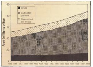
Figure 6. Projections of land-cover change in the Cerrado biome based on government census statistics through 1985. The area of cultivated (planted) pasture in 1985 (30,000,000 ha) is approximately equivalent to the total area of forest cleared in the closed-canopy forests of Amazonia as of 1988.[95]
Cerrado has one of the richest savanna floras in the world. According to Heringer et al. [99] of the 774 woody species, 429 composed the proper floristic stock of the Cerrado, 300 species belong to the forest formations and the remaining 45 to other vegetation types. This number of the 429 unique woody savanna species is not matched by any other savanna flora in the world. The number of herbaceous species is still unknown.
Cerrado occupation
Cerrado exploitation started with the Portuguese searching for precious minerals and Indians for slave amend in the 16th century. The first permanent settlements were established in the early 18th century and were associated with gold mining. Some farming developed among the mining communities, but economic activity shifted to cattle raising with the exhaustion of the mines. A new wave of exploration began in the middle of the 19th century after the Paraguay war and during the 1920-1930 period, stimulated by the coffee boom in São Paulo state.[13]
Two main factors were responsible for the modern occupation of Cerrado. The construction of Brasília, Brazil’s new capital, in the late 50s, and the adoption of development policies and investments in infrastructure between 1968 and 1980. The construction of highways allowed the occupation of space and the expansion of commercial agriculture in Cerrado.
“The science campaign represents an excellent opportunity to analyze the changes that have taken place in this vast biome”
The policies with the highest impact on agricultural expansion were subsidized credit, tax exemption on agricultural activities, minimum prices for crops, subsidies to fuel, and the development of farming technology suitable to the regions climatic and soil conditions.[95] So besides have favored commercial crops at the expense of staple crops and the environment. Since concession loans were available in the proportion of crop area (not production) they had a dramatic impact on the nature of development and the area cleared.[13]
As a consequence of the expansion of agriculture, total Cerrado population grew from 6.5 million in 1970 to 12.6 million in 1991. Throughout the region, there has been a strong trend towards urbanization and decline of the rural population. Almost a fourth of the population concentrates around the metropolitan areas of Brasília and Goiânia, Goiás state capital.
Cerrado land-use
Until 30 years ago the region was used primarily for extensive cattle rising. Today it is estimated that 37% of this natural vegetation has been transformed into cultivated pastures, crop fields, dams, urban settlements, and degraded areas.[15]
The most significant forms of land-use are cultivated pastures and commercial crops mainly soybeans, corn, rice, coffee, beans, and manioc (see Table 3). Cerrado production of soybeans in 1994 was 8.8 million tons (1/4 of the national production). Cerrado corn comprises 16% of the national production, rice 13%, coffee 8%, beans 11%, and manioc 5%.
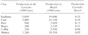
Table 3. Agricultural production in the Cerrado and in Brazil in 1990.
(IBGE 1990, cited in Klink et al.[98])
The cattle herd also displayed substantial growth between 1970 and 1985: from 16.6 million to 38 million animals. Cultivated pastures have grown from 8.7 million hectares to 38 million in the same period. The delay in the release of census information makes it difficult to determine cattle growth in recent years.
Projections of the evolution of the main crops, cultivated pastures, and open areas indicate the future of land-use in the Cerrado. In 1985, 51 million hectares of land had been cleared in this region. It is estimated that the area of cleared land in 1994 was 70 million hectares, equivalent to 39% of the total area of the region. Considering appropriate conditions for agricultural expansion, good market conditions, and changes in economic policies, the total area of cleared land in the Cerrado will be 88 hectares in 2000, representing 49% of the Cerrado land surface.
The transformation of natural landscapes in the Cerrado it’s causing water pollution, soil erosion, fragmentation of vegetation, extinction of wildlife, invasion of exotic species, and modification of the fire regime.[13]
Recommendations
The lack of information on land-use in the Cerrado biome is remarkable given the amount of attention that the scientific community has given to the closed canopy forest biome of the Amazonia. The LBA science campaign should complete TM-basic mapping of land cover change in that area of the Cerrado Biome that is within or close to the legal Amazon. Similar to the recommendations for the closed canopy forest of Amazonian, information is needed to predict the future geographic trends in Cerrado visitation conversion and the logic that is adopted by the farmers and landholders who manage the vegetation. The science campaign represents an excellent opportunity to analyze the changes that have taken place in this vast biome, much of which drinks through the Amazon estuary, and much of which has already been severely altered by land-use practices.